
M 9.1 (USGS) - 2004 Sumatra - Andaman Islands Earthquake
- 2004-12-26 00:58:53 (UTC)
- 3.295°N 95.982°E
- 30.0 km depth
- 2004-12-26 00:58:53 (UTC)
- 3.295°N 95.982°E
- 30.0 km depth
Tectonic Summary
The devastating M 9.1 earthquake off the west coast of northern Sumatra on December 26, 2004, occurred as the result of thrust faulting on the interface of the India plate and the Burma microplate. In a period of minutes, the faulting released elastic strains that had accumulated for centuries from ongoing subduction of the India plate beneath the overriding Burma microplate.
In a broad sense, the India and Australia plates move towards the north-northeast with respect to the interior of the Eurasia plate with velocities of about 60 mm/yr in the region of the earthquake. This results in oblique convergence at the Sunda Trench, about 200 km to the southwest of the December 26th earthquake. The oblique motion is partitioned into thrust faulting, which occurs on the interface between the India plate and the Burma microplate and involves slip directed at a large angle to the orientation of the trench, and strike-slip faulting, which occurs on the eastern boundary of the Burma microplate and involves slip directed approximately parallel to the trench. Details of the velocity of the Burma microplate remain to be determined and may, in fact, be clarified by further analysis of the December mainshock and its aftershocks.
Early models of the December 26th mainshock fault displacement differ in many details, but are consistent in implying that fault rupture propagated to the northwest from the epicenter and that substantial fault rupture occurred hundreds of kilometers northwest of the epicenter. The data upon which the modeling is based do not permit confident resolution of the extent of rupture beyond about 500 km northwest of the mainshock epicenter. The width of the earthquake rupture, measured perpendicular to the Sunda Trench, was about 150 km, and maximum displacement on the fault plane was upwards of 20 m. The sea floor overlying the thrust fault was uplifted by several meters as a result of the earthquake, causing the ensuing tsunami that devastated shores around the Indian Ocean.
The zone of aftershocks of the December 26th earthquake is more than 1,300 km long. Because aftershocks occur on and very near the fault planes of mainshocks, the length of the aftershock zone suggests that mainshock fault rupture may have extended north of the epicenter by an amount significantly larger than 500 km. However, a great earthquake may also trigger earthquake activity on faults that are distinct from the mainshock fault plane and separated from it by tens or even hundreds of kilometers. Detailed modeling of this earthquake over the months and years following the event, using teleseismic data (that the models discussed here were based on) and data from regional global positioning system (GPS) stations, indicates that significant slip extended over a region up to about 1,500 km to the north of the epicenter, and that rupture lasted for more than 500 seconds.
This is the third largest earthquake in the world since 1900 and is the largest since the 1964 Prince William Sound, Alaska, earthquake. Since 1900, earthquakes similarly sized or larger than the December 26th earthquake have been the M 9.0 1952 Kamchatka earthquake, the M 9.5 1960 Chile earthquake, and the M 9.2 1964 Prince William Sound, Alaska, earthquake. All of these earthquakes, like the December 26th earthquake, were megathrust events, occurring where one tectonic plate subducts beneath another. All produced destructive tsunamis, although fatalities and damage from the December 26th tsunami have far exceeded those caused by tsunamis associated with the earlier earthquakes and was documented nearly worldwide on tide gages.
Hayes et al. (2016) Tectonic summaries of magnitude 7 and greater earthquakes from 2000 to 2015, USGS Open-File Report 2016-1192. (5.2 MB PDF)
Comparison of Fault Rupture Area to Size of California

Downloads
For More Information
Origin
Catalog Mag Time Depth Review Status Location Source 9.1 mw 00:58:53 30.0 km REVIEWED 3.295°N 95.982°E OFFICIAL 3 US 4 US 9.0 mwc 00:58:53 30.0 km REVIEWED 3.295°N 95.982°E US 4 HRV GCMT 9.0 mwc 00:58:50 10.0 km AUTOMATIC 3.300°N 95.780°E US 4 CHOY 8.5 me 00:58:53 30.0 km REVIEWED 3.300°N 95.980°E US 4 ISCGEM 9.0 mw 00:58:53 30.0 km AUTOMATIC 3.331°N 95.952°E US 4 ISCGEM DUPUTEL 9.2 mww 00:58:50 13.5 km AUTOMATIC 3.600°N 94.077°E US 4 DUPUTEL Contributed by OFFICIAL 3 US 4
- The data below are the most preferred data available
- The data below have been reviewed by a scientistMagnitude
- The data below are the most preferred data available
- The data below have been reviewed by a scientistMagnitude
M 9.1 (USGS) - 2004 Sumatra - Andaman Islands Earthquake
Distance and direction from epicenter to nearby place.
Tectonic Summary
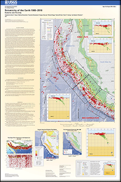
Seismotectonics of the Sumatra Region
The plate boundary southwest of Sumatra is part of a long tectonic collision zone that extends over 8000 km from Papua in the east to the Himalayan front in the west. The Sumatra-Andaman portion of the collision zone forms a subduction zone megathrust plate boundary, the Sunda-Java trench, which accommodates convergence between the Indo-Australia and Sunda plates. This convergence is responsible for the intense seismicity and volcanism in Sumatra. The Sumatra Fault, a major transform structure that bisects Sumatra, accommodates the northwest-increasing lateral component of relative plate motion.
Relative plate motion between the Indo-Australia and Sunda plates is rapid, decreasing from roughly 63 mm/year near the southern tip of Sumatra (Australia relative to Sunda) to 44 mm/year north of Andaman Islands (India relative to Sunda) and rotating counterclockwise to the northwest, so that relative motion near Jakarta is nearly trench-normal but becomes nearly trench-parallel near Myanmar. As a result of the rotation in relative motion along the strike of the arc and the interaction of multiple tectonic plates, several interrelated tectonic elements compose the Sumatra-Andaman plate boundary. Most strain accumulation and release occurs along the Sunda megathrust of the main subduction zone, where lithosphere of the subducting Indo-Australia plate is in contact with the overlying Sunda plate down to a depth of 60 km. Strain release associated with deformation within the subducting slab is evidenced by deeper earthquakes that extend to depths of less than 300 km on Sumatra and 150 km or less along the Andaman Islands. The increasingly oblique convergence between these two plates moving northwest along the arc is accommodated by crustal seismicity along a series of transform and normal faults. East of the Andaman Islands, back- arc spreading in the Andaman Sea produces a zone of distributed normal and strike-slip faulting. Similar to the Sumatran Fault, the Sagaing Fault near Myanmar also accommodates the strike-slip component of oblique plate motion. Plate-boundary related deformation is also not restricted to the subduction zone and overriding plate: the subducting Indo-Australian plate actually comprises two somewhat independent plates (India and Australia), with small amounts of motion relative to one another, that are joined along a broad, actively-deforming region producing seismicity up to several hundred kilometers west of the trench. This deformation is exemplified by the recent April 2012 earthquake sequence, which includes the April 11 M 8.6 and M 8.2 strike-slip events and their subsequent aftershocks.
Paleoseismic studies using coral reefs as a proxy for relative land level changes associated with earthquake displacement suggest that the Sunda arc has repeatedly ruptured during relatively large events in the past, with records extending as far back as the 10th century. In northern Simeulue Island, the southern terminus of the 2004 megathrust earthquake rupture area, a cluster of megathrust earthquakes occurred over a 56 year period between A.D. 1390 and 1455, resulting in uplift substantially greater than that caused by the 2004 event. Studies that look at large sheeted deposits of sand on land interpreted as the transport of debris from a tsunami wave also indicate that this region has experienced significant tsunamis in the past centuries, albeit infrequently.
Prior to 2004, the most recent megathrust earthquakes along the Sumatran-Andaman plate boundary were in 1797 (M 8.7-8.9), 1833 (M 8.9-9.1) and 1861 (M8.5). Since 2004, much of the Sunda megathrust between the northern Andaman Islands and Enggano Island, a distance of more than 2,000 km, has ruptured in a series of large subduction zone earthquakes - most rupturing the plate boundary south of Banda Aceh. The great M 9.1 earthquake of December 26, 2004, which produced a devastating tsunami, ruptured much of the boundary between Myanmar and Simeulue Island offshore Banda Aceh. Immediately to the south of the great 2004 earthquake, the M 8.6 Nias Island earthquake of March 28, 2005 ruptured a 400-km section between Simeulue and the Batu Islands. Farther south in the Mentawai islands, two earthquakes on September 12, 2007 of M 8.5 and M 7.9 occurred in the southern portion of the estimated 1797 and 1833 ruptures zone, which extends from approximately Enggano Island to the northern portion of Siberut Island. Smaller earthquakes have also been locally important: a M 7.6 rupture within the subducting plate caused considerable damage in Padang in 2009, and a M 7.8 rupture on October 25, 2010 occurred on the shallow portion of the megathrust to the west of the Mentawai Islands, and caused a substantial tsunami on the west coast of those islands.
In addition to the current seismic hazards along this portion of the Sunda arc, this region is also recognized as having one of the highest volcanic hazards in the world. One of the most dramatic eruptions in human history was the Krakatau eruption on August 26-27, 1883, a volcano just to the southeast of the island of Sumatra, which resulted in over 35, 000 casualties.
Subduction and seismicity along the plate boundary adjacent to Java is fundamentally different from that of the Sumatran-Andaman section. Relative motion along the Java arc is trench-normal
(approximately 65-70 mm/year) and does not exhibit the same strain partitioning and back-arc strike- slip faulting that are observed along the Sumatra margin. Neither has the Java subduction zone hosted similar large magnitude megathrust events to those of its neighbor, at least in documented history. Although this region is not as seismically active as the Sumatra region, the Java arc has hosted low to intermediate-magnitude extensional earthquakes and deep-focus (300-700 km) events and exhibits a similar if not higher volcanic hazard. This arc has also hosted two large, shallow tsunami earthquakes in the recent past which resulted in high tsunami run-ups along the southern Java coast.
Seismicity of the Earth 1900–2012 Sumatra and vicinity
Compiled by Gavin P. Hayes, Melissa Bernardino, Fransiska Dannemann, Gregory Smoczyk, Richard Briggs, Harley M. Benz, Kevin P. Furlong, and Antonio Villaseñor
The plate boundary southwest of Sumatra is part of a long tectonic collision zone that extends over 8,000 km from Papua, New Guinea, in the east to the Himalayan front in the west. The Sumatra-Andaman part of the collision zone forms a subduction zone plate boundary, which accommodates convergence between the Indo-Australia and Sunda plates. This convergence is responsible for the intense seismicity in Sumatra. The Sumatra Fault, a major transform structure that bisects Sumatra, accommodates the northwest-increasing lateral component of relative plate motion.
|
First posted August 8, 2013
For additional information contact:
Director, Geologic Hazards Science Center U.S. Geological Survey Box 25046, MS-966 Denver Federal Center Denver, CO 80225-0046 http://geohazards.cr.usgs.gov/
Part or all of this report is presented in Portable Document Format (PDF); the latest version of Adobe Reader or similar software is required to view it. Download the latest version of Adobe Reader, free of charge.
|
Suggested citation:
Hayes, G.P., Bernardino, Melissa, Dannemann, Fransiska, Smoczyk, Gregory, Briggs, Richard, Benz, H.M., Furlong, K.P., and Villaseñor, Antonio, 2013, Seismicity of the Earth 1900–2012 Sumatra and vicinity: U.S. Geological Survey Open-File Report 2010–1083-L, scale 1:6,000,000, https://pubs.usgs.gov/of/2010/1083/l/.
Keine Kommentare:
Kommentar veröffentlichen